
Many Americans are concerned about Tropical Storm Imelda’s path, especially as it is expected to develop into Hurricane Imelda over the next few days. As of Monday, September 29, some rain and heavy winds from Imelda will be felt along the eastern coast of Florida. Several days ago, weather models projected that the most likely path for the tropical storm was that it would move north toward North Carolina and South Carolina. But the current forecast has Imelda changing its track sharply in large part due to the strength of Hurricane Humberto nearby.
What is the latest update on Tropical Storm Imelda’s track?
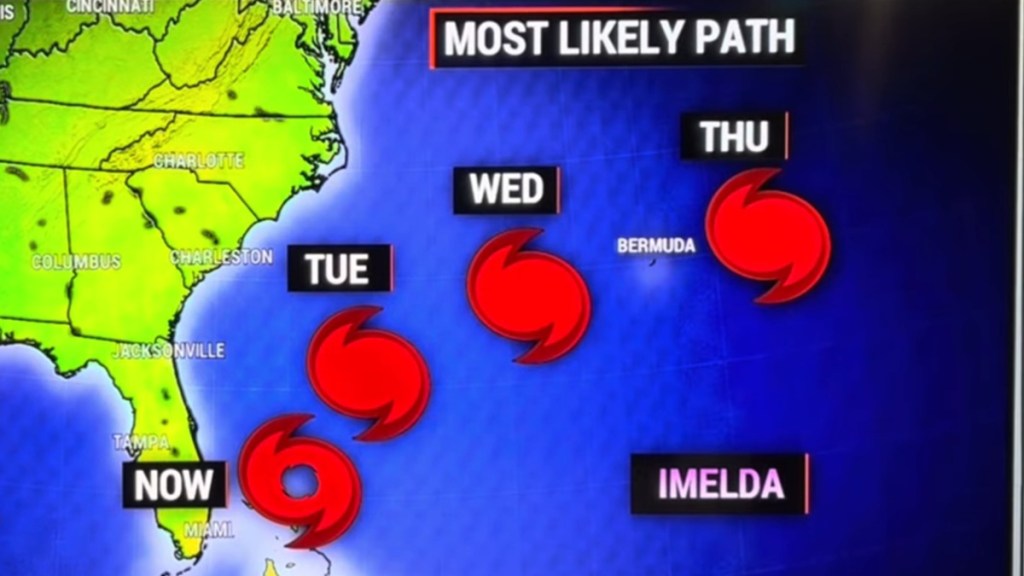
Models on September 29 believe that Tropical Storm Imelda will continue north along the eastern US coastline but then make a sharp turn east away from the United States on Tuesday morning.
This forecast comes by way of NOAA and meteorologist Brian Shields. This means that by the time it becomes a Category 1 hurricane (or perhaps a Category 2), Imelda will be heading over the Atlantic Ocean without making landfall in the United States. That said, the current track for the storm has it making a direct hit on Bermuda by Wednesday morning.
Last week, it was originally expected that Hurricane Humberto would not be able to impact the development of Tropical Storm Imelda significantly in the hopes that it would pull the storm east. But since then, Humberto has become a Category 5 storm that has moved passed Imelda to its northeast. The power of Humberto and its proximity to Imelda by Tuesday means that it will be able to spin Imelda toward the east due to the Fujiwhara effect, a phenomenon where two large storm systems close together will make them rotate around a center point between them.
The forecast for Imelda has it diminishing in strength after it passes Bermuda, downgrading back to a tropical storm by Saturday, October 4.


