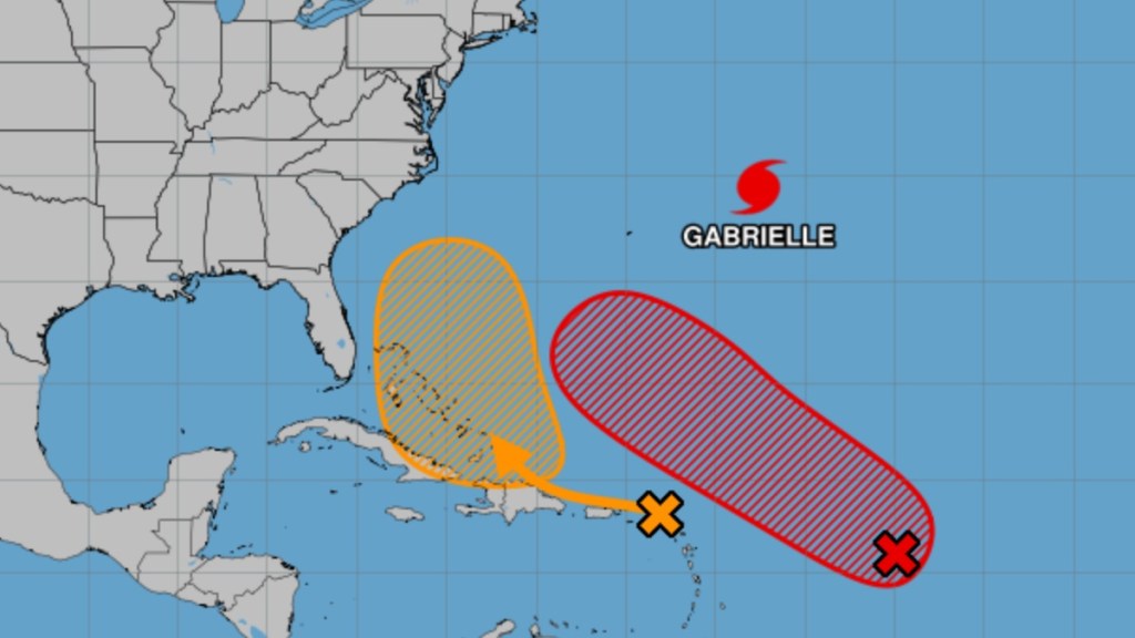
Weather experts are looking at the possibility of a hurricane or tropical storm hitting the southeastern United States, particularly Florida, by the end of the week in September 2025. While the Category 4 Hurricane Gabrielle heads east across the Atlantic Ocean, two separate systems in the Caribbean could become named systems over the next several days, with one that has the chance of heading toward the eastern coast of Florida. This system could be called Tropical Storm Humberto or Imelda, and then Hurricane Humberto or Imelda, depending on which of these storms strengthens faster.
When could the next hurricane hit Florida?
The next hurricane could hit Florida by Sunday, September 28, give or take a few days. As of September 23, the system that could impact the United States within a week is causing heavy rain, up to 6 inches, in the northern Caribbean, notably the islands of Antigua and Barbados.

This Sunday projection is provided by meteorologist Brian Shields (more commonly known as Mr. Weatherman on YouTube), who has been looking at weather models in the region. Accuweather believes that Florida could feel the impacts of the system as early as September 26. As noted in the image above, a September 23 from The National Oceanic and Atmospheric Administration (NOAA) conservatively gives a 60% chance for the system to develop into a major storm.
What makes these predictions tricky is due to there being two systems that are developing side by side in the Caribbean (the areas colored yellow and red in the image). It’s possible that they might combine into one system, though chances are that they will continue to grow as separate storms. Still, very high ocean temperatures from 86 to 88 degrees in the Caribbean provide the fuel needed to elevate the storm into a tropical storm and then a hurricane.
On September 23, three weather models forecast that the storm is on track to become a hurricane that could go through The Bahamas and hit Florida. Its path is still uncertain as it’s still early in the week and the storm is still forming. Also, a cold front moving across the southeastern US could move this system to the east, which would mean that it could be pushed back into the Atlantic.


